Nexus — dive boat routing & marine intelligence
Naval-Grade Intelligence & Routing
Abyss Nexus is an advanced marine intelligence engine built for dive operations in complex coastal and archipelagic environments. It combines route computation, coastal shielding analysis, vessel physics, weather interpretation, and fuel modeling into a single operational layer. The result is not a simple map feature, but a high depth decision engine designed to evaluate navigability, exposure, efficiency, and real world route viability before departure.
1. Real World Marine Routing
Not straight lines. Not guesswork. Real navigable paths.
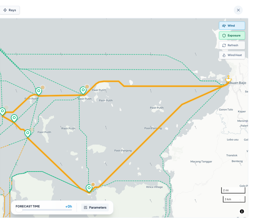
Abyss Nexus uses a route computation engine designed for complex marine environments, not simplified map logic. Instead of drawing a straight line between two points, it generates realistic over water paths across archipelagos, coastal constraints, and operational corridors. The system evaluates weighted route networks in real time, allowing it to identify viable paths that reflect how boats actually move through fragmented marine geography. This makes Nexus fundamentally different from basic mapping tools. It is not route visualization. It is route computation.
2. Coastal Shielding Intelligence
Because offshore weather is not the same as on route weather.
Nexus analyzes how coastlines, islands, bays, and landmasses alter real exposure along a route. Each path is broken into micro segments, then tested against environmental vectors to determine whether wind and swell are fully exposed or partially blocked by surrounding terrain. This allows the engine to detect protected corridors, downgraded wave exposure, and localized shelter effects that broad forecast layers cannot capture. The result is a far more realistic understanding of what the boat is likely to experience on the water.
3. Vessel Physics Engine
Different boats react differently. Nexus knows that.
Abyss Nexus does not treat every vessel as if it behaved the same way. Its physics layer applies vessel specific performance logic to model how different hull types respond to headwind, crosswind, wave impact, and speed. A traditional wooden displacement boat, a fast transfer hull, and a heavier charter platform do not lose efficiency in the same way under the same conditions. Nexus accounts for those differences through hydrodynamic heuristics and environmental penalty factors, making its route analysis operationally relevant rather than mathematically generic.
4. Fuel Curve & Efficiency Modeling
Speed has a cost. Slower is not always cheaper.
Nexus models fuel performance using non linear propulsion logic rather than flat hourly assumptions. Instead of assuming fuel burn scales in a simple way, the system applies a power based curve to estimate how propulsion demand evolves with speed. It also separates propulsion load from passive onboard loads such as generators and hotel systems, which is critical for real world dive operations. This makes it possible to evaluate not only route duration, but route efficiency, fuel penalty, and the true speed sweet spot where liters per nautical mile are optimized.
5. Dynamic Weather Matrix
Weather is interpreted against heading, angle, and state.
Abyss Nexus does more than ingest forecast data. It reinterprets weather against the actual geometry of the route and the orientation of the vessel. Wind angle, swell direction, bow exposure, cross angle loading, and wave period are all evaluated dynamically across the route profile. This means Nexus does not assign one static condition to an entire trip. It computes how the boat interacts with changing environmental forces segment by segment, producing a far more intelligent operational picture than raw forecast overlays alone.
6. Operational Compute Architecture
Built for live operations, not fragile dashboards.
Nexus is designed as a computation engine for real time marine decision support. Heavy spatial and environmental analysis is offloaded from the interface layer to backend and edge processing pipelines, allowing the system to remain responsive while deeper calculations continue asynchronously. This architecture makes fast rendering possible without sacrificing analytical depth. It also supports resilient fallback behavior, so if external weather inputs fail or time out, the system can safely degrade into a fallback projection instead of freezing, crashing, or interrupting the planning workflow.
Nexus exists to turn marine complexity into operational clarity. It helps teams understand not just where a boat can go, but how exposed the route is, how the vessel is likely to behave, and what the efficiency tradeoff looks like before the day starts. For operators working in dynamic environments, that difference is critical.
Experience marine intelligence.
Launch the interactive engine to visualize topography intercepts, fuel parabolas, and edge computing in action right now in your browser.